Waterfalls
–––––June 16, 2026, is International Waterfall Day, and there is no better time of year than spring to early summer to explore the thundering waterways of Shenandoah National Park. The park has more than a dozen named waterfalls, and dozens more course through the Blue Ridge Mountains and the Alleghany Mountains nearby.
Here are links to a few of Shenandoah’s most popular waterfall hikes that are accessible via trailheads along Skyline Drive:
OVERALL RUN FALLS HIKING TRAIL
- Skyline Drive Mile: 21.1
- Waterfall Height: 93 ft
- Hike Difficulty: Moderately Strenuous
- This is the tallest waterfall in the park showcasing an impressive drop as well as an impressive view. The hike is a 6.5-mile (10 km) round trip hike with a climb of 1850 ft. It is recommended you go before June as this waterfall tends to dry up.
- Pet-Friendly Hike 🐾: Yes
- Skyline Drive Mile: 49.4
- Height: 67 ft
- Hike Difficulty: Moderate
- This 2.6-mile (4 km) round trip hike rewards you with a cascading waterfall that has been known to feature up to 4 cascades in rainy weather. This moderate hike will elevate 720 feet.
- Pet-Friendly Hike 🐾: Yes
- Skyline Drive Mile: 50.7
- Waterfall Height: 70 ft
- Hike Difficulty: Moderate
- 1.4 mile (2 km) round trip hike. This is the closest waterfall to Skyline Drive and the most popular. The trail is only a 1.4 miles round trip hike but has a 440 ft. elevation. Please be aware that some points are very steep and can be demanding on your return but there are plenty of places to safely rest on your way back up.
- Pet-Friendly Hike 🐾: No
- Skyline Drive Mile: 51.4
- Waterfall Height: 81 ft
- Hike Difficulty: Moderate
- This hike is a 2.5-mile (4 km) round trip hike with an elevation of 795 feet. It will provide you with a side view of the magnificent falls. Please be aware this is a rocky descent with some very steep parts. We recommend going early in the season or after rainfall for the best water flow.
- Pet-Friendly Hike 🐾: Yes
- Skyline Drive Mile: 62.8
- Waterfall Height: 83 ft
- Hike Difficulty: Moderate
- This hike will take you to the 3rd tallest waterfall in Shenandoah. This 3.3-mile (5 km) loop hike brings you to an overlook above the falls which is an 850-foot climb where you can see the water thunder down to the ground.
- Pet-Friendly Hike 🐾: Yes
BROWNS GAP WATERFALL HIKING LOOP
- Skyline Drive Mile: 83
- Hike Difficulty: Easy/Moderate
- This 6.5 Mile Loop hike includes both Doyles River Falls and Jones Run Falls and loops you back on part of the Appalachian Trail.
- Pet-Friendly Hike 🐾: Yes
- Skyline Drive Mile: 81.1
- Upper Falls Height: 28 ft
- Lower Falls Height: 63 ft
- Hike Difficulty: Moderate
- There are 3 possible hikes for these falls ranging from 2.7 miles (4.3 km) to 7.8 miles (12.5 km) round trip including views of the upper and lower falls as well as the longest loop hike that goes by Jones Run Falls. The elevation gains for these hikes range from 850 to 1,825 feet.
- Pet-Friendly Hike 🐾: Yes
- Skyline Drive Mile: 84.1
- Height: 42 ft
- Hike Difficulty: Moderate
- This is a 3.6-mile (5.8 km) round trip hike with a climb of 915 feet that can also be turned into a longer loop hike that goes by Doyles River upper and lower falls (see Browns Gap Waterfall hiking loop). This is a gradual climb that features a picturesque waterfall surrounded by vegetation.
- Pet-Friendly Hike 🐾: Yes
Always Practice Common Sense Safety Rules Around Waterfalls
Stay on the trail and think safety-first. When rocks get wet they tend to get slippery so keep this in mind and stay away from edges. Always bring water and be sure to dress appropriately. Wear sturdy hiking shoes. Remember that your cellphone and GPS may not always work when you are in the park.
###
Pictured above: Upper Rose Rover Falls: NPS/Brett Raeburn
Civilian Conservation Corps
 The CCC “boys” did not construct the roadbed of the Drive as has at times been suggested. But there would be no Skyline Drive without the efforts of the CCC. They graded the slopes on either side of the roadway, built the guardrails and guard walls, constructed overlooks, planted hundreds of thousands of trees and shrubs and acres of grass to landscape both sides of the roadbed, built the picnic areas and campgrounds, comfort stations, visitor contact and maintenance buildings, and made the signs that guided visitors on their way. Many served as the first park interpreters.
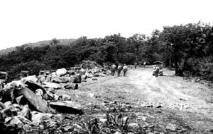
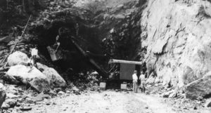 Marys Rock Tunnel
The tunnel, 670 feet long, was bored through the solid granite of Marys Rock in 1932. Although justified as avoiding the necessity of creating an expensive cut on the existing slope and filling the down slope areas, thus creating a massive man-made visual feature, it has been suggested that the tunnel was built as a challenge to Bureau of Public Roads and National Park Service landscape architects. The tunnel was partially lined with concrete in 1958 to alleviate the formation of icicles in winter and water seepage in summer—a partially successful effort.
Guard Walls and Guard Rails
The CCC built many of the stone walls along the Drive, particularly those in the South District and those at overlooks. Beginning in 1983 many of the original walls have been rebuilt by the Federal Highways Administration with cores of concrete, reusing the original stone as a veneer. When built, the Skyline Drive had miles of chestnut log guardrails, particularly in areas of open fields and meadows. The guardrails rotted and all were removed in the 1950s, not to be replaced.